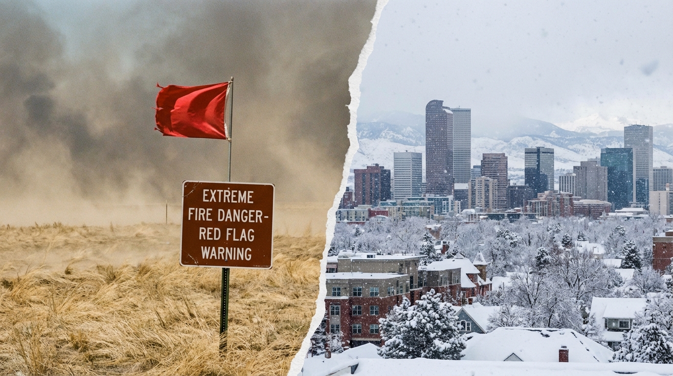
Denver Weather: Record Warmth and Critical Fire Danger
The atmosphere over the Front Range is currently behaving less like a winter stabilization pattern and more like a loaded spring, ready to snap. For residents and long-time observers of the High Plains, the current state of denver weather is not merely a topic of small talk; it has become a critical indicator of regional safety and environmental volatility. We are currently staring down the barrel of a meteorological setup that combines the comfort of record warmth with the terror of extreme fire danger, a duality that is becoming increasingly common in the modern Colorado climate narrative.
The Anatomy of a Red Flag Crisis
This week, the immediate concern is not the cold, but the combustion potential. Meteorological models have aligned to create a scenario that fire weather forecasters dread: the convergence of high velocity and low moisture. We are seeing a setup where the atmosphere is wringing out what little moisture remains in the soil and vegetation.
According to a recent analysis by KDVR, the region has entered a “Pinpoint Weather Alert” status specifically for Tuesday. This designation is not used lightly. It signals a day where the ordinary activities of urban and suburban lifegrilling, parking a car over tall grass, or operating machinerycan have catastrophic consequences.
The specific mechanics driving this threat are classic downsloping winds. As air creates a pressure gradient across the Rockies, it descends onto the Front Range, compressing and warming. This process, often referred to as the Chinook effect, acts as a massive hair dryer aimed directly at the Denver metro area. The result is a rapid plummet in relative humidity, often dipping into the single digits, paired with wind gusts that can strip shingles off roofs and, more dangerously, carry embers for miles.
Shattering Historical Thermometers
While the wind poses the immediate physical threat, the temperatures tell a deeper, perhaps more unsettling story about our climatic trajectory. We are not just seeing a warm spell; we are witnessing the rewriting of the record books. The persistence of high pressure ridges over the western United States has blocked the typical flow of arctic air, allowing the southwest desert heat to expand northward.
Data reported by 9News indicates that Colorado has set records for the warmest winter days recently. This is statistically significant. When winter days consistently perform like late April or early May, the biological clock of the local flora is disrupted. Trees begin to bud prematurely, and the dormancy that usually protects vegetation from drying out is broken.
This “false spring” phenomenon is deceptive. It invites residents outdoors and lowers the psychological barrier to fire safety. When it feels like a beach day in February or March, the instinctual caution regarding heating sources or sparks often fades. However, the vegetation remains dead or dormantessentially standing haywaiting for an ignition source.
The Tinderbox Effect
The correlation between these warm, windy days and fire behavior cannot be overstated. We are looking at fuel moisture levels that are critically low. In fire science, we talk about “1-hour,” “10-hour,” and “100-hour” fuels, referring to how long it takes vegetation to react to changes in humidity. Under the current conditions described by CBS News, the finer fuelsgrasses and shrubsare flash-drying almost instantly.
The CBS report highlights that strong winds coupled with these warm, dry conditions are the primary drivers for the high fire danger. It is a formula that residents of the Marshall Fire burn scar know too well. Wind speeds ranging from 20 to 40 mph, with gusts potentially hitting 60 mph or higher in the foothills, mean that no fire containment is guaranteed. Aerial resources are often grounded in such turbulence, leaving ground crews to fight fast-moving grass fires that can outpace a vehicle.
Meteorological Whiplash
One of the defining characteristics of the Front Range is the speed at which the pendulum swings. We are currently bracing for what can best be described as “weather whiplash.” The atmosphere rarely sustains this level of energy without a correction. The same systems that draw up warm air ahead of a trough eventually crash the cold air down behind it.
As noted in the coverage by 9News, the state is bracing for “wild weather.” This implies a drastic shift. It is entirely within the norm for Denver to experience a 70-degree day with high fire danger, followed 24 hours later by freezing drizzle or snow. This rapid cycling puts immense stress on infrastructure. Potholes bloom as asphalt expands and contracts, and power lines stressed by wind are then weighed down by precipitation.
For the average citizen, this requires a dual-preparedness mindset. You must have your go-bag ready for evacuation due to fire, while simultaneously ensuring your vehicle has winter tires and emergency blankets for a blizzard. It is a cognitive dissonance that is unique to the Intermountain West.
The Human and Economic Toll
Beyond the charts and the warnings, there is a tangible impact on the daily lives of Denverites. The relentless wind and dust kick up allergens, creating a public health nuisance that fills urgent cares with sinus and respiratory complaints. The psychological toll of “Red Flag” days is also mounting. In a post-2021 world, high wind events are no longer just noisy; they are triggering for thousands of people living in the Wildland-Urban Interface (WUI).
Insurance markets are also reacting to this volatility. The frequency of these high-wind, high-fire-risk days is a key metric used by actuaries to determine rates. As “unprecedented” weather becomes the baseline, the cost of living in these fluctuating zones increases. We are seeing a shift where weather is not just a backdrop, but an active economic participant in the region.
Furthermore, the agricultural sector faces confusion. The record warmth tricks perennials. If a hard freeze follows this heatwhich is statistically probable given the time of yearwe could see significant damage to fruit trees and early crops. The erratic nature of the temperature swings makes planning nearly impossible for farmers and gardeners alike.
Navigating the New Normal
What we are observing this week is likely a preview of the future climate reality for the Colorado Front Range. The data suggests that shoulder seasonsspring and fallare becoming more turbulent. The jet stream patterns that drive these systems are showing signs of greater amplitude, leading to more stuck patterns of heat followed by violent corrections.
It is essential to move beyond viewing these reports as isolated events. The connection between the record warmth cited by 9News and the critical fire weather cited by KDVR is causal, not coincidental. Heat dries the landscape; pressure gradients drive the wind; the wind spreads the fire. It is a closed loop of risk that requires constant vigilance.
Frequently Asked Questions
Q: What exactly constitutes a Red Flag Warning in Denver? A: A Red Flag Warning is issued by the National Weather Service when critical fire weather conditions are either occurring or imminent. In Denver, this typically involves a combination of strong winds (usually sustaining 15+ mph or frequent gusts), low relative humidity (often 15% or lower), and warm temperatures that create a high potential for rapid fire growth.
Q: How does the current warm spell compare to historical winters? A: Recent data indicates we are experiencing some of the warmest winter days on record. This is part of a broader trend of warming winters in the Mountain West, where persistent high-pressure systems block arctic air, allowing temperatures to soar well above seasonal averages.
Q: Why is the wind so strong in Denver during warm spells? A: This is often due to downsloping winds. As air flows from the high mountains down to the lower elevation of the plains, it compresses and warms up. This process increases the speed of the wind and drastically lowers the humidity, creating the warm, windy “Chinook” conditions.
Q: Can we expect snow after this heat and fire danger? A: Yes, it is very common. The low-pressure systems that drag up warm, windy air ahead of them often have a cold front trailing behind. As the system passes, the wind direction shifts, temperatures plummet, and precipitation (often snow) can follow rapidly.
Conclusion
As we navigate this week of extremes, the message from the meteorological community is clear: complacency is the enemy. The denver weather patterns we are seeingrecord-breaking heat followed by high-velocity windsare clear signals of a volatile atmosphere. Whether it is securing loose outdoor items, avoiding any outdoor burning, or simply staying aware of the rapid changes in the forecast, the responsibility falls on the community to adapt to these sharp fluctuations. The beauty of the Rockies comes with a price, and that price is often a weather landscape that can turn from benign to dangerous in a matter of hours.