Winter Storm Watch: Analyzing the February 2026 Forecast
The atmosphere along the Eastern Seaboard is charged with a familiar tension this week, as meteorologists and municipal planners alike scrutinize a complex weather pattern developing off the coast. We are currently in a precarious window of uncertainty where the potential for a significant winter storm watch is high, yet the precise mechanics of the system remain elusive. While the calendar reads mid-February 2026, the atmospheric setup bears the hallmarks of classic historical Nor’easters, threatening to disrupt the lives of millions along the I-95 corridor. The question on everyone’s mind is not just if it will snow, but whether we are facing a manageable dusting or a crippling blizzard.
TL;DR
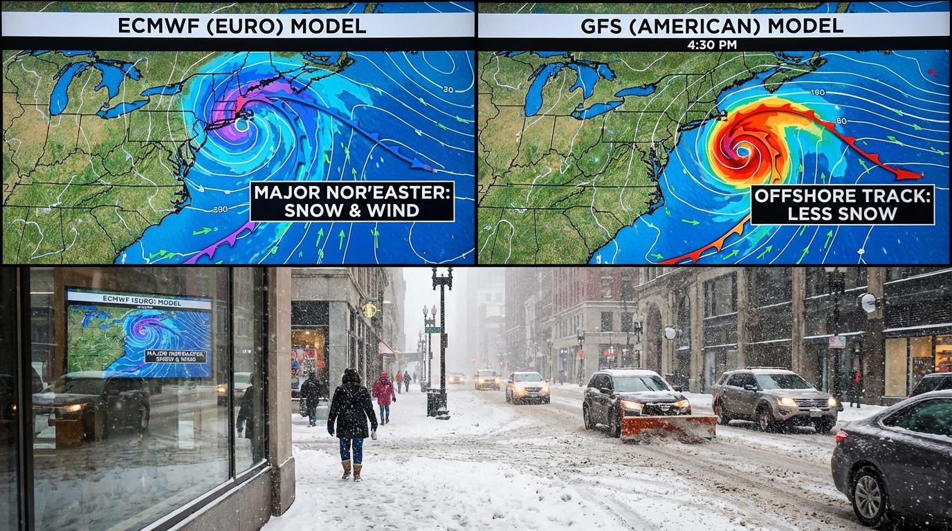
- Model Disagreement: Major forecast models (GFS and ECMWF) are currently showing conflicting tracks, creating uncertainty regarding snow totals.
- Timing: The system is expected to impact the region late Friday through Sunday, potentially disrupting weekend travel.
- Impact Zone: The highest risk areas include major metropolitan hubs from Philadelphia to Boston.
- Preparation: Residents should prepare for potential power outages and travel bans, regardless of the final accumulation numbers.
- Status: While not yet a full-blown warning, the situation warrants close monitoring of local alerts.
The Science of Uncertainty: A Model Standoff
In the world of investigative meteorology, few things are as frustrating or as fascinating as a split decision between major global forecast models. As we approach the weekend, we are witnessing a significant divergence between the American GFS model and the European ECMWF model. According to CNN, the American model is currently favoring a track that pushes the storm further out to sea, which would spare the coast from the heaviest accumulation. Conversely, the European model suggests a tighter phasing of the northern and southern jet streams, a scenario that typically results in rapid cyclogenesis or a “bomb cyclone” hugging the coastline.
This lack of consensus is not merely an academic debate; it has real-world consequences for logistical planning. The difference of fifty miles in the storm’s track can mean the difference between a cold rain and two feet of heavy, wet snow. The complexity lies in the energy transfer between two distinct disturbances. If they merge early, the East Coast gets hammered. If they remain separate, the storm remains a maritime curiosity rather than a terrestrial hazard. This “phasing” is notoriously difficult to predict more than three days out, leading to the current state of meteorological whiplash.
The Infrastructure Gamble
For city managers and department of transportation officials, this uncertainty translates into a high-stakes financial gamble. Mobilizing a fleet of snowplows and salting trucks costs hundreds of thousands of dollars per day in overtime and materials. If a city declares a snow emergency based on a pessimistic forecast that fails to materialize, they face public backlash and budget deficits. However, failing to prepare for a storm that does hit can lead to paralyzed infrastructure and threats to public safety.
Reports indicate that NBC New York is tracking the potential for plowable snow specifically for the tri-state area, highlighting that even the lower-end estimates require significant pretreatment of roads. The challenge is exacerbated by the timing; a weekend storm impacts retail and leisure travel differently than a weekday commute, shifting the focus from keeping highways clear for workers to ensuring safety for shoppers and travelers. The economic ripple effect of a shutdown in New York City or Boston alone is measured in the billions, making the accuracy of these mid-range forecasts economically vital.
Decoding the Alerts: When to Worry
Understanding the Winter Storm Watch Criteria
It is crucial for the public to understand the terminology used by the National Weather Service, as confusion often leads to either panic or complacency. A winter storm watch is issued when there is a potential for significant hazardous weather within 48 hours. It does not mean the storm is guaranteed; it means the ingredients are there. This is distinct from a “warning,” which means the hazardous weather is imminent or occurring. Currently, we are in the observation phase, where the data is being refined every six hours as weather balloons and satellite data feed into the supercomputers.
During a watch, the primary action item is preparation, not panic. This is the window to check emergency kits, ensure generators are fueling, and adjust travel plans. The psychological impact of these alerts often leads to the “milk and bread” phenomenon, stripping grocery shelves bare. However, a more investigative look at consumer behavior suggests that modern supply chains are resilient enough to handle these surges provided the storm duration is short. The real danger lies in power infrastructure, particularly if the snow is wet and heavy, capable of snapping lines and toppling trees.
Comparison table
The following table breaks down the leading forecast models and their current stance on the upcoming system, helping readers understand the variance in predictions.
| Option | Best for | Pros | Cons | Pricing/Cost |
|---|---|---|---|---|
| European Model (ECMWF) | Long-range accuracy and coastal storms | Historically more accurate with jet stream phasing; higher resolution data. | Can sometimes overestimate precipitation totals in the 5-day range. | N/A (Public Data) |
| American Model (GFS) | General trends and rapid updates | Updates frequently (4 times a day); often catches shifts in storm tracks early. | Has a historical tendency to push storms too far out to sea (progressive bias). | N/A (Public Data) |
| Canadian Model (GEM) | Cold air damming scenarios | Good at predicting low-level cold air locking in place. | often an outlier compared to Euro/GFS consensus. | N/A (Public Data) |
| ICON (German) | Short-range precision | High resolution for specific localized impacts. | Less reliable for long-range synoptic patterns over the Atlantic. | N/A (Public Data) |
Pros and cons
When facing a potential weather event with high uncertainty, decision-makers and residents must weigh the benefits of early aggressive action against the costs of false alarms.
Pros of Aggressive Early Preparation
- Safety: Reduces the risk of stranded motorists and accidents on untreated roads.
- Resource Allocation: Ensures crews and equipment are positioned before conditions deteriorate.
- Supply Chain: Allows grocery stores and fuel stations to restock ahead of the panic buying surge.
- Infrastructure Protection: Pre-treating roads with brine prevents ice bonding, making cleanup significantly faster.
Cons of Aggressive Early Preparation
- Economic Cost: Municipalities burn through budget reserves for overtime and materials that may not be needed.
- Public Fatigue: Repeated “cry wolf” scenarios lead to the public ignoring future, potentially more dangerous warnings.
- Disruption: Premature school and business closures result in lost productivity and revenue.
- Environmental Impact: Excessive use of road salt damages local waterways and vegetation if applied unnecessarily.
The Human Element and Forward Outlook
Beyond the isobar lines and precipitation charts, there is a human story developing. Weather.com notes that this storm comes at a time when winter fatigue is setting in. The resilience of communities is tested not just by the weather, but by the cumulative stress of the season. If the models converge on a major impact solution, we will see a rapid transition from scientific debate to emergency management. The next 24 hours are critical. If the weather balloons launched this evening show a stronger dip in the jet stream, the American model will likely correct westward, bringing the heavy snow back into the I-95 cities.
Investigating the historical context, storms in late February often carry more moisture due to slightly warmer Atlantic ocean temperatures compared to January. This increases the risk of “thundersnow” and rapid accumulation rates of 2-3 inches per hour. Such rates make it impossible for plow crews to keep up, necessitating total travel bans. The data suggests that while the exact track is in flux, the energy available in the atmosphere is undeniable. We are looking at a potent system; the only variable left is the precise geometry of its arrival.
FAQ
Q: How likely is it that the forecast will change completely before the weekend? A: It is moderately likely. In winter weather forecasting, the “track” is everything. A shift of just 50 miles can change a forecast from 12 inches of snow to a cold rain. The models usually converge about 48 hours prior to the event.
Q: What is the difference between a Winter Storm Watch and a Winter Weather Advisory? A: A Winter Storm Watch indicates the potential for a major storm (heavy snow, ice, or sleet) is significant but not guaranteed. A Winter Weather Advisory is issued for less severe conditions that will cause inconveniences but are not expected to be life-threatening if caution is exercised.
Q: Should I cancel my weekend travel plans now? A: It depends on your flexibility. If you have non-refundable tickets or critical plans, it is wise to have a backup. If you are driving, waiting until the models converge (likely by Thursday) is a safer bet before making final decisions.
Q: Why do the European and American models disagree so often? A: They use different mathematical equations and data assimilation methods to simulate the atmosphere. The European model runs at a higher resolution and has historically handled complex jet stream interactions slightly better, but the American model has seen significant upgrades in recent years.
Conclusion
As we stand on the precipice of this potential meteorological event, the only certainty is the volatility of the forecast. The coming days will require vigilance and flexibility from residents along the East Coast. Whether this system evolves into a historic blizzard or drifts harmlessly out to sea, the mechanisms at play highlight the immense complexity of predicting our atmosphere. Residents are advised to keep a close eye on local forecasts, as the issuance of a winter storm watch will be the first definitive signal that the threat has transitioned from theoretical to imminent. Preparation is the antidote to panic; ensuring you are ready for the worst-case scenario is the most prudent course of action in the face of nature’s unpredictability.